transverse Mercator map projection
- transverse Mercator map projection
A conformal cylindrical map projection, which is in principle equivalent to the regular Mercator map projection turned (transversed) 90° in azimuth. In this projection, the central meridian is represented by a straight line, corresponding to the line that represents the equator on the regular Mercator map projection. Neither the geographical meridians (except the central meridian) nor the geodetic parallels (except the equator) are represented by straight lines. Also called an inverse cylindrical orthomorphic map projection; an inverse Mercator map projection; and a transverse cylindrical orthomorphic map projection.
The Mercator projection.
Northern Hemisphere transverse Mercator projection with the 0° Greenwich Meridian shown as the central meridian of the projection. The shaped area extended 600 NM either side of the central meridian is the central meridian is the only part of the projection that is of practical navigation use.
Aviation dictionary.
2014.
Look at other dictionaries:
Map projection — A medieval depiction of the Ecumene (1482, Johannes Schnitzer, engraver), constructed after the coordinates in Ptolemy s Geography and using his second map projection A map projection is any method of representing the surface of a sphere or other … Wikipedia
Transverse Mercator projection — The transverse Mercator projection is an adaptation of the Mercator projection. Both projections are cylindrical and conformal. However, in the transverse Mercator, the cylinder is rotated 90° (transverse) relative to the equator so that the… … Wikipedia
Universal Transverse Mercator coordinate system — The Universal Transverse Mercator (UTM) coordinate system is a grid based method of specifying locations on the surface of the Earth. It is used to identify locations on the earth, but differs from the traditional method of latitude and longitude … Wikipedia
Irish Transverse Mercator — (ITM), is the new geographic coordinate system for Ireland. It was implemented jointly by the Ordnance Survey of Ireland (OSI) and the Ordnance Survey of Northern Ireland (OSNI) in 2001. The name is derived from the Transverse Mercator projection … Wikipedia
cylindrical projections/cylindrical equal-area map projection — A cylindrical map projection onto a cylinder tangent to a sphere, showing the geographic meridians as a family of equal spaced parallel straight lines perpendicular to a second family of parallel straight lines. They represent the geographic… … Aviation dictionary
Mercator projection — of the world between 82°S and 82°N. Mercator world … Wikipedia
Map — /map/, n. Walter, c1140 1209?, Welsh ecclesiastic, poet, and satirist. Also, Mapes /mayps, may peez/. * * * I Graphic representation, drawn to scale and usually on a flat surface, of features usually geographic, geologic, or geopolitical of an… … Universalium
map — mappable, adj. mapper, n. /map/, n., v., mapped, mapping. n. 1. a representation, usually on a flat surface, as of the features of an area of the earth or a portion of the heavens, showing them in their respective forms, sizes, and relationships… … Universalium
MAP — See modified American plan. * * * I Graphic representation, drawn to scale and usually on a flat surface, of features usually geographic, geologic, or geopolitical of an area of the Earth or of any celestial body. Globes are maps represented on… … Universalium
New Zealand Map grid — The New Zealand Map Grid (NZMG) is a map projection based on the New Zealand Geodetic Datum 1949.[1] It has now been replaced by the New Zealand Transverse Mercator 2000 projection, which is based on the New Zealand Geodetic Datum 2000 using the… … Wikipedia
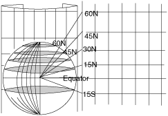 The Mercator projection.
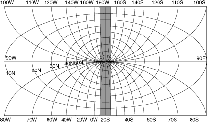 Northern Hemisphere transverse Mercator projection with the 0° Greenwich Meridian shown as the central meridian of the projection. The shaped area extended 600 NM either side of the central meridian is the central meridian is the only part of the projection that is of practical navigation use.